Modeling
Groundwater models constitute nowadays backbones in Applied Hydrogeology to provide accurate solutions almost to all issues related to groundwater resources evaluation, exploitation, management, protection and prediction. RGC has over 30 years of experience in groundwater modeling in numerous countries. Some projects are listed below.
Modeling of a complex volcanic system and planning sustainable exploitation of groundwater resources. The Borena Basin in Southern Ethiopia.
-
Data interpretation and design of the conceptual model.
-
GW Flow Analysis. Identification of boundary conditions.
-
Calibration using the Pilots Point approach.
-
Water balance estimation. Sustainable yield estimation.
-
Wellfields discharge rates optimization.
This work has been published in the journal Water and can be downloaded freely. Ref. Water 2020, 12, 276; doi:10.3390/w12010276


On Borena site, during a flood event.
With M.Likissa (Hydrogeologist OWWDSE, Addis Ababa, Ethiopia)
Modeling of the Shinile basin (Eastern Ethiopia). Assessment of groundwater resources and optimization of the resources exploitation.
-
Data interpretation (Geology, Geophysics, Hydrochemistry, Isotopes).
-
Boundary conditions. Recharges processes. Conceptual model.
-
Design of the conceptual model. Design of the numerical model
-
Calibration of the model using a geostatistical approach
-
Analysis of the model results. Water balance estimation
-
Wellfields pumping rates optimization


On Shinile site, with M. Geletu, Hydrogeologist OWWDSE, Addis Ababa, Ethiopia.
Photo : artesian well in the Shinile basin.
Modeling of 5 aquifers, including two coastal aquifers, in the Republic of Djibouti. within a project of the Ministry of Environment and the UNEP. Analysis of climate change impacts. Tadjourah and Obock coastal aquifers, Arta aquifer, Ali-Sabieh aquifer and Dikhil aquifer.
-
Data interpretation and design of the conceptual model, in each case.
-
Design of a 3D model for coastal aquifers and 2D models for inland aquifers.
-
Calibration of the models. Estimation of the water balance.
-
Assessment of the equilibrium state between seawater and freshwater in Tadjourah and Dikhil aquifers.
-
Prediction of climate change impact until 2100, based on IPCC climate scenarios.
-
Analysis of the availability and sustainability of groundwater resources.
-
Analysis of groundwater quality degradation at wellfields exploiting the coastal aquifers.
The work about the Tadjourah coastal aquifer has been published in the journal Water and can be downloaded freely. Ref. Water 2019, 11(11), 2347; https://doi.org/10.3390/w11112347

Progress of seawater intrusion in the vicinity of the town of Obock. Climate change impact according to IPCC scenarios

Modeling of a coastal aquifer in arid context. The Foum El Oued aquifer (Morocco)
-
Data interpretation and design of the conceptual model
-
Calibration in steady and transient regimes using a zone wise approach and PEST
-
Seawater intrusion simulation
-
Wellfield pumping rates optimization.
-
Artificial Recharge of the aquifer. Simulation of various facilities.
-
Simulation of the risks of the wellfield contamination by urban wastewater discharges


Wellfield contamination risks analysis using a transport model and simulation of seawater intrusion.
Modeling of an alluvial aquifer and analysis of the risks of contamination of wells from a waste’s disposal site.
-
Data interpretation and design of the conceptual model.
-
Calibration of the flow model.
-
Performing tracing tests and estimating transport parameters.
-
Development of the transport model.
-
Simulation of contamination risks.


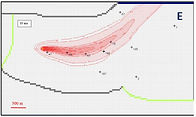
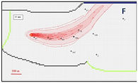
The flow model (A) and propagation of the contaminant plume at various times (B to F)
Assessment of inter-basins groundwater transfer using numerical modeling. Case of Blue Nile and Upper Awash basins (Ethiopia).
-
Data interpretation (Hydrogeology, Geology, Geophysics, Hydrochemistry, Isotopes).
-
Analysis of the hydrogeological systems, including the Blue Nile Plateau (adjacent to Awash basin) and the Upper Awash basin.
-
Aquifers structures and boundaries.
-
Understanding the structural setting.
-
Analysis of groundwater flow and of groundwater-surface water relations.
-
Estimation of GW recharge.
-
Calibration of the model using a geostatistical approach.
-
Analysis of the model results. Estimation of groundwater inter-basins transfer.
-
Assessment of wellfields vulnerability to pollutants in Upper Awash.


On the site of Awash Basin. With Dr T.Azagegen (left) and Dr W.Furi (right) of Addis Ababa University.
Modeling of the Mekelle outlier (Northern Ethiopia). Assessment and optimal groundwater resources exploitation.
-
Data interpretation (Geology, Geophysics, Hydrochemistry, Isotopes). Role of the fractures network
-
System geometry including lateral and depth extent.
-
Groundwater head distributions. Boundary conditions.
-
Recharges processes. Water budget of the system.
-
Design of the conceptual model. Design of the numerical model
-
Calibration of the model using a geostatistical approach
-
Water balance estimated by the model.
-
Wellfields pumping rates optimization.


Calibration of the Mekelle groundwater model. W-E Cross-section showing the role of major structures


With Mr Desta Horecha, Head of DH Water Supply Engineering Service, during a field trip on the Mekelle outlier and the adjacent Rift valley (photo on the right). Mountains in the background are the eastern border of the Mekelle plateau.